Road navigation
During stakeout or when reviewing the road, the left of the screen shows the road in the map or cross section view.
The panel to the right of the Review screen shows information about the part of the road you have selected in the map or cross section view.
The panel to the right of the Stakeout navigation screen shows the navigation pane.
-
The arrow points in the direction of the point that you intend to measure (the "target").
-
The stakeout delta values at the bottom of the navigation pane indicate the distance to and the direction of the target.
When navigating to a point during stakeout, the information shown depends on whether you are performing a Conventional or GNSS survey, and the options you have configured in the Stakeout options screen.
-
To configure navigation display options, including values for Grade and Design Cut/Fill, see Stakeout navigation display.
-
To change the displayed deltas during stakeout, tap Options in the stakeout navigation screen or tap and hold in the navigation pane.
-
To view the as-staked point details before you store the point, enable the View before storage setting.
The stakeout navigation screen shows the map view or cross section view of the road.
Map
The map shows:
- Horizontal alignment as a red line
- Other strings as black lines
- Construction offsets as green lines
- Skew offsets as dashed black lines
During stakeout the map shows a dashed green line drawn from the current position to the:
- horizontal alignment when measuring your position relative to the road and you are within 30 m of the alignment/string
- selected string when measuring your position relative to a string and you are within 5 m of the string
Cross section view
To view the cross section of the road, tap ![]() in the map toolbar.
in the map toolbar.
When viewing a road design file:
-
The cross section view shows the strings and templates relative to the alignment. It also shows any surface added as well as the surface calculated from the road design.
-
The cross section is orientated in the direction of increasing station. Your current position and the target are shown. If the target has construction offsets specified, the smaller single circle indicates the selected position and the double circle indicates the selected position adjusted for the specified construction offset(s). The construction offset(s) appear as green lines.
-
The appropriate cut or fill side slope appears for the side of the road that you are currently on.
If you have set the Design cut/fill field to Perpendicular in the Stakeout options screen, the perpendicular cut/fill position is drawn on the design in the cross section view only when measuring positions relative to the road. Because the cross section view is not drawn to scale, the perpendicular position may appear slightly incorrect (ie. not exactly perpendicular).
-
Tap and hold in the cross section view to define a cross slope or subgrade.
-
To step through the templates for the road, tap the arrow keys. To set a fixed scale based on the widest template in the road, tap
 . To use a variable scale so that each template fills the cross section view, tap
  .
.
When viewing strings and surfaces:
-
Strings have no relationships to each other until you select them.
-
The cross section view shows only the surface used – it cannot show any calculated surface.
To return to the map, tap ![]() .
.
Assign the Toggle Plan / Cross section function to a function key on the controller so that you can switch between the plan and cross section views when reviewing and staking a road.
Before stakeout the software shows:
- Station (when staking a station on a string)
-
String name (when staking a station on a string or measuring your position relative to a string)
For an RXL road, the software uses the string name from the template definition. When the offset is 0.000 m, the string name defaults to CL.
- Design elevation of the selected position (shown in red if edited)
- Construction offsets
- When staking a station on a string, the software also shows:
- Type
- Offset
- Elevation (shown in red if edited)
- When staking a side slope, the software also shows the:
- Design side slope values
- Cut ditch width (RXL roads only)
- When staking a skew offset, the software also shows the:
- Skew offset
- Deflection angle/azimuth
During stakeout the software shows:
- Elevation of your current position (shown in blue)
- When staking a side slope, the software also shows:
- Side slope value defined by your current position (shown in blue)
- Design side slope value (shown in red if edited)
- Off road appears if your current position is before the start of the road or beyond the end of the road.
-
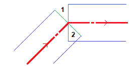
Undefined appears when consecutive horizontal alignment elements are non tangential and your current position is beyond the end tangent point of the incoming element but before the start tangent point of the next element and you are on the outside of the road. See position 1 in the diagram below.
-
When consecutive horizontal alignment elements are non tangential and your current position is before the end tangent point of the incoming element but after the start tangent point of the next element, and your position is on the inside of the road (see position 2 in the diagram below), the station, offset and vertical distance values are reported using the closest horizontal element to your position to determine which portion of the road to use.
The bottom of the navigation pane shows stakeout delta values that report your current position relative to the item being staked.
To change the displayed deltas during stakeout, tap Options in the stakeout navigation screen or tap and hold in the navigation pane.
- If you are using a conventional instrument, the road values only appear after you take a distance measurement.
- If the road consists of only a horizontal and vertical alignment the V.Dist value reports the vertical distance to the vertical alignment.
- When using a road design file, if your position is in a gap, the V. Dist value is null. Gaps are shown as a dashed line in the cross section view. To see how to create a gap in a template, see To add templates.
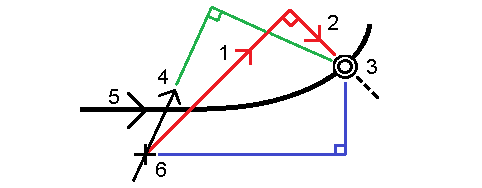
During stakeout, hold the display screen in front of you as you walk forwards in the direction that the arrow is pointing. The arrow points in the direction of the point that you intend to measure (the "target").
As shown in the diagram below, the values in the Go Forward/Go Backward (1) and Go Right/Go Left (2) fields are relative to the cross‑section of the point that you are staking out (3). They are not relative to the current direction of travel (4), or to the direction of increasing station (5) at your current position (6).
The behavior at stakeout differs depending on whether the offset/string was selected from the map or cross section view, selected from a list, or keyed in.
- If you select a string from the map or cross section view, or select a string from the list, the Go Right/Go Left value at stakeout updates to reflect any changes in geometry due to template changes or widening.
- If you key in a numeric offset value (effectively defining a string on the fly) that value is maintained for the entire length of the road.
Consider the following diagram:
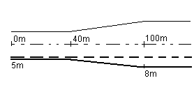
If you select an offset/string that has an offset value of 5 m, the offset value updates to follow the solid line for subsequent stations. In this example, the offset changes from 5 m to 8 m between stations 40 m and 100 m and then is maintained at 8 m for subsequent stations.
If you key in 5 m for the offset, the offset follows the dashed line. That is, the offset of 5 m is maintained for subsequent stations.
When using a GNSS receiver with a built-in tilt sensor, you can:
- Tap eBubble to display an electronic bubble
- Configure the survey style to prompt a warning when the pole is outside a specified Tilt tolerance
- To configure quality control, precision, and tilt settings, tap Options.