Subgrades
Define a subgrade when the cross section represents the finished road surface and you need to stake the points defining other surfaces in the road – typically the subgrade.
-
Subgrades can be used when staking from a road design file. Subgrades cannot be used when staking Strings and surfaces.
-
You cannot define a subgrade from the Stakeout method screen or when measuring your position relative to a road or a string.
Subgrade points are computed by creating a temporary line that is parallel to, and offset from, a line between two strings in the cross section. The points can then be selected for stakeout:
To define a subgrade
-
From the plan or cross section view, tap Subgrade and follow the on-screen prompts to define the subgrade.
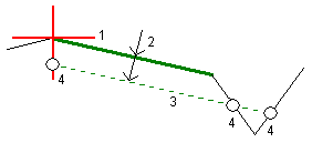
The selected line (1) appears as a bold green line. The depth to subgrade (2) is from the selected line to the subgrade surface. A dashed green line (3) extends to intersect with all encountered lines in the cross section. If no intersection(s) are found, computed points are created at the same start and end offsets as that of the selected line. The single circles (4) indicate the computed positions.
You cannot define a subgrade by selecting a line that defines a side slope.
-
Tap Accept.
- Tap the position that you want to stake.
- Navigate to the target and then stake the position.
To stop using the subgrade
To de‑activate the subgrade function, tap Subgrade and tap Clear and then tap Close.