String interpolation
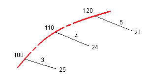
When the LandXML cross section road is redefined as an RXL road, the cross-sections are computed by determining where the cross-section line, formed at right angles to the alignment cuts the strings associated with the alignment. For interpolated stations the offset and elevation values for the position on an associated string is interpolated from the offset and elevation values of the previous and next positions on that string. This ensures the integrity of the design, especially on tight arcs.
See the following example, where the cross section at station 100 has a string offset from the alignment by 3 and an elevation of 25. The next cross section at station 120 has a string offset by 5 and an elevation of 23. The position on the string for the interpolated station 110 is interpolated as shown to give an offset of 4 and an elevation of 24.